Description
The Tease. (Bronx Bike Ride Maritime College)
To many, Throgs Neck is just a bridge. To cyclists, it’s a frustrating one, as there’s no bike path over it. But Throgs Neck is also a community on Eastchester Bay. And the bridge passes over SUNY’s Maritime College, which sits on a peninsula at the southeastern edge of The Bronx and houses a historic fort as well as an institute of higher learning.
The Deep Dive.
This ride starts on the edge of a gritty industrial area. Don’t be fooled by the start, most of the ride is peaceful and on the water. This is also one of many rides that should be getting better soon. Or rather “soon.” There are planned bike paths through Ferry Point Park, which is directly south of where this ride begins at the intersection of Ferry and Brush. But they’ve been in the works for a decade.
You’re heading in a straight line for East Chester Bay. If tarrying is your yen, you can stop to snack on East Tremont Ave. When Lafayette ends, you’re just about on the water. Turn right to follow the water’s edge south.
When you can’t go south any more because the land ends, you turn right onto Schley Avenue and follow it to its end, where it runs into the Throgs Neck Expressway. Parallel the expressway south until you come to your first intersection. Make a right and go under the highway. You’re on this road until its end.. Make a left at the guard station and you’re on college property.
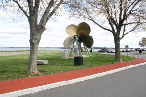
You’re now following the road with the water is on your left. This will take you under the Throgs Neck Bridge and to Fort Schuyler, which is at the very tip of the peninsula. On your left, is a tiny spit of land, a peninsula off the peninsula, a spot that’s great for setting down in the grass or at a picnic table.
The first street that actually goes somewhere is Schurz Avenue. In time, you should be able to take this road into Ferry Point Park and almost all the way back to the start, but for now, there’s no route through, so turn right just before the road ends onto Hosmer, and then follow the edge of the par, so it’s on your right until you get to St. Raymond’s Cemetery. Then, follow the edge of the cemetery until you’re at the Cross Bronx Expressway Extension, where you’ll make a left and ride it until you get to Lafayette, where the ride ends.
Specs (Bronx Bike Ride Maritime College)
Borough(s): The Bronx
Distance: 8.2 miles
Elevation: 181 feet
Terrain: Nearly flat. Most of the elevation is very gradual
Ride Rating: @@
Notes: This is The Bronx at possibly its most remote. It’s a peninsula cut off from the rest of the borough, but still pretty easy to get to. Fort Schuyler feels like an outpost on the edge of the sea. Bx10 and Bx05 are nearby.
Includes: A PDF to print out or put on your phone. A GPX file for your phone or GPS-enabled bike computer.
If you need a tutorial, here’s where you find that info. https://jralong.com/wheretobikenyc/2020/06/18/download-a-ride/