
$4.50
Borough(s): Staten Island, Distance: 3.9 miles, Elevation: 129′. Terrain: Flattish, Ride Rating: @.
Description
Teaser
Mount Loretto Unique Area, as it is officially known, is a New York State Park. But it’s a new one, having been purchased from the Mission of the Immaculate Virgin in 1999. The Mission ran the largest orphanage in New York State, serving both boys and girls, and was a working farm as well as a school. Times have changed and the state purchased the land to keep it out of the hands of developers.
More Detail
While there is a working farm in Queens, it’s surrounded by highways and busy roads. This loop gives you a sense of what a more agrarian Staten Island might have looked like, from an era before the bridges attached this little island to the New York archipelago and New Jersey.
Mount Loretto (Staten Island Bike) takes you on a tour of the Pleasant Plains section of Staten Island, an area once dominated by the orphanage for which this ride is named. The land both north and south of Hylan between Sharrot and Cunningham was once orphanage property. The kids living on the grounds allegedly grew their own food, milked their own cattle, collected their own eggs, and even made their own clothes. Whether or not this was a good thing, we’ll let others decide, but when the grounds, some 400 acres in total, were bought in 1871, kids as young as six years old were living on the streets of New York City. The Mission owned a ten-story building in Greenwich Village before they bought and built up this space.
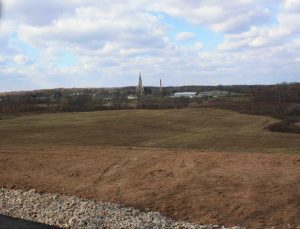
Now that the grounds are in state hands, the area can possibly return to what it looked like before it was farmed. The 194-acre tract south of Hylan is a combination of grasslands, wetlands (both freshwater and tidal), and coastal shoreline. All are popular with animals, and both birdwatchers and butterfly fans that spend time in Mount Loretto will find plenty to tell their friends about. It could be a quirk of geography, but the shoreline, which is a mile long, is supposedly the last undeveloped shoreline in the state.
When riding around the area, you’ll find that the Unique Area seems to be a transplant from a much more rural community. Flanders came to mind for us, thanks to the church building that stands on the grounds north of Hylan.
Conclusion
But even with the large public park, the reality of suburbia intrudes, but only after taking in the Unique Area and turning onto Amboy Road. Even though Amboy feels narrow and crowded, there are few houses and almost no cross streets until you make the turn off it and start heading back to the start. In all, there is very little of this ride where public parkland isn’t on one or both sides of the road you’re pedaling down. And that makes the riding good.
Stats
Borough(s): Staten Island
Distance: 3.9 miles
Elevation: 129′
Terrain: Flattish, a few rises. Traffic is pretty light.
Ride Rating: @
Notes: A state forest in New York City. Red clay bluffs, too
Includes: A PDF with intelligence, a GPX file to upload to your bike computer or mobile device.
Print out the PDFs or put them on your phone. Put the GPX files on your phone or a GPS-enabled bike computer. Pump up your tires. Get on your bike. Go!
If you need a tutorial, here’s where you find that info: Download Rides.
LInks to: SI07 (if you have a mtb), SI08, SI10
