
$4.50
Borough(s): Staten Island, Distance: 7.7 miles, Elevation: 271′, Terrain: Somewhat hilly. Busier at the start, but gets lighter as you go. Ride Rating: @@
Description
Starting at the start.
The Staten Island Ferry to Fort Wadsworth Loop, while an out-and-back, should serve as a gateway to most of the rides on Staten Island. It runs along the shore, and, so long as you keep the water on your left, you can start here and ride all the way to Tottenville, and take in Staten Island rides 03, 05, 06, 07, 08, 09, and 10. This route starts as one of the most urban and industrial of the rides laid out in Staten Island, but the payoff, Fort Wadsworth, is bucolic.
The Story
Since most New Yorkers who want to ride in Staten Island and live on another island will be getting there by ferry, we start with riding from the ferry itself. The problem with starting at the ferry is that it’s a major transit point for locals. That means there can be quite a bit of car traffic when you’re leaving the ferry terminal if you happen to go at the wrong time.
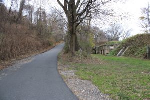
That’s why this course quickly skirts the busy thoroughfare of Bay Street and takes you down to the water. Quiet industrial roads like Front Street show a working city, and give a brief glimpse into the island’s seafaring past. But once you feel like you’ve got the rhythm down, you turn and are suddenly thrust into a suburban downtown that almost as quickly gives way to Fort Wadsworth.
Wadsworth is part of Gateway National Recreation Area, much like Floyd Bennett Field, is a decommissioned military installation. Gateway, which is part of the National Park Service, has their area headquarters in Wadsworth. All the same, it still houses military personnel, so some of the grounds are off limits to the public.
At the far end of the ride, you loop under the Verrazano Narrows Bridge and ride past the lower fort, Battery Weed. Weed, originally Fort Richmond, was built in the mid 19th century to protect New York City from naval attack.
Once past it, you climb up to get onto Mont Sec Avenue, an officers’ row, before turning back to retrace your route back to the ferry.
After riding on quiet and largely abandoned streets most of the way, the turn onto Bay Street is a bit disconcerting, but it means you’re only a few blocks from finishing the ride.
Specifics (Ferry Wadsworth Bike Ride)
Borough(s): Staten Island
Distance: 7.7 miles
Elevation: 271′
Terrain: Somewhat hilly. Busier at the start, but gets lighter as you go.
Ride Rating: @@
Notes: The area around the ferry has been changing for years and will change more for years. Fort Wadsworth is the opposite. It’s largely stuck in the 19th and early 20th century.
Includes: A PDF with intelligence and a GPX file to upload to your bike computer or mobile device. Print out the PDFs or put them on your phone. Put the GPX files on your phone or a GPS-enabled bike computer. Pump up your tires. Get on your bike. Go!
If you need a tutorial, here’s where you find that info: Download Rides.
